Last Updated on March 11, 2025
Entirely surrounded by scenic mountain peaks, ancient rivers, and cozy coves, Western North Carolina provides an outdoor setting like no other. And the unincorporated hamlet of Cedar Mountain sits right in the thick of it. With what seems like thousands of miles of well-managed trails within just a small radius, Cedar Mountain locals enjoy the outdoor playgrounds they find right in their back yards.
Take time to explore this amazing area and breathe in our fresh mountain air! Here are five hikes within five miles of Cedar Mountain, NC.
Editor’s Note: Many state parks were affected by Hurricane Helene in late September 2024. To the best of our knowledge, the trails listed here are open as of when this post was published, but the progress of trail repairs continues to change regularly. Check for any trail closures before you begin your hike, and be sure to follow all current posted safety precautions.
Lake View Loop Trail
Length: 0.23 miles (loop)
Difficulty: Easy
DuPont State Recreational Forest abounds with, well, opportunities to recreate. There are enough hiking trails to keep you busy for a lifetime. But among our favorites is the short and easy Lake View Loop. The quarter-mile loop is easily accessible from Lake Julia Road and offers views of the water. A dock and picnic tables are nearby, offering plenty of opportunities to spend an entire day enjoying the mountains and water. For those more interested in a hike, the Lake View Loop can be reached at the end of the moderately difficult, 5.3-mile Reasonover Creek Trail, which features beautiful wildflowers along its path. Learn more.
Burnt Mountain Trail
Length: 3.9 miles (loop)
Difficulty: Moderate
Tucked along the edge of DuPont State Forest, the 3.9-mile Burnt Mountain Trail is possibly the most challenging Cedar Mountain hike on this list—though still considered only moderately difficult. The trail is popular with mountain bikers, as it follows an old road bed, and features beautiful wildflowers along the route. While Burnt Mountain Trail does take you to the mountain summit, it’s the winding path along the Little River that makes it worth trying. For a more scenic experience, take some side trails down to the river. When the weather is right, you may catch a few low-running waterfalls. This trail connects to the Corn Mill Shoals Trail to complete the loop. Learn more.
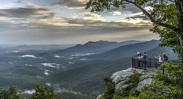
Caesars Head Overlook
Length: 0.3 miles (loop)
Difficulty: Easy
Head down US-276 from Cedar Mountain, and four miles later, past the South Carolina state line, is Caesars Head State Park. The park is named for a granitic gneiss outcropping atop the dramatic Blue Ridge Escarpment. The peak’s overlook along a paved boardwalk is easily accessible, treating hikers to incredible views of nearby Table Rock Mountain (seen at top). On clear days, you may even be able to spot distant Greenville. In the fall, thousands of hawks migrate through the park, offering additional wonders. There is a small fee for trail access, but a dedicated parking lot is open from 9:00 AM–6:00 PM. And their visitors center makes a great stop either before or after hitting the trail. Learn more.
Editor’s Note: Trail access for Caesars Head Overlook is currently open during business hours and is listed as “hike at your own risk”.
Raven Cliff Falls Trail
Length: 2.2 miles (out and back)
Difficulty: Moderate
Among the 60+ miles of challenging trails in Caesars Head State Park is the four-mile-round-trip Raven Cliff Falls Trail. This popular hiking trail leads to another scenic overlook from which you can view the 420-foot Raven Cliff Falls. There is also a 6.6-mile round trip hike to a suspension bridge that crosses the creek above Raven Cliff Falls. The bridge offers a unique view of the falls as they plunge deep into the mountain cove below. If you enjoy waterfall hikes, you’re in luck! Five additional waterfalls are accessible throughout Caesars Head State Park, including Rainbow Falls. Learn more.
Jones Gap Falls Trail
Length: 3.0 miles (out and back)
Difficulty: Moderate
Rounding off our adventures over the SC state line is a hike along Jones Gap Trail. Caesars Head connects to Jones Gap State Park by what is known as the Mountain Bridge Wilderness Area. This 13,000-acre area of pristine Southern mountain forest is not to be missed! When reopened, hikers can take a number of loop and traverse hiking trails that connect the parks, including the more extensive Jones Gap Loop Trail. South Carolina’s first designated scenic river, the Middle Saluda River, runs through Jones Gap. In addition to great trout fishing, hikers can enjoy dipping into swimming holes along the river. The park also features a living lab for their hand-on ecology learning center. Learn more.
Find a home near Cedar Mountain, NC
Located along the North Carolina-South Carolina line, Cedar Mountain is an unincorporated community in NC’s Transylvania County—the perfect place to call “home.” This single county offers over 100,000 acres of public land via Pisgah National Forest, DuPont State Forest, Headwaters State Forest, and Gorges State Park, offering myriad outdoor activities such as hiking, hunting, and fishing. In addition to countless outdoor adventures, Transylvania County offers eclectic in-town living with many opportunities for education, art, and music. The county seat of Brevard is just one local and welcoming community, with properties that range from historic single-family homes to downtown condos and new construction.
Does that sound like the perfect lifestyle for you? Find your perfect mountain home in Transylvania County now!