Last Updated on June 6, 2023
Do you feel like you’ve hiked and biked every sidewalk, trail, and unofficial footpath in your neighborhood? Are you looking for new wilderness to roam?
It’s easy to find the path less traveled without going too far!
In Western North Carolina, you can explore nearby trails your entire life and still find something new. And because we’re Official Sponsors of NC Year of the Trail, we know just the ones to try that are less traveled among people itching to escape the house and enjoy spring sunshine.
We challenge you to learn more about NC Year of the Trail and the best new-to-you trails to inspire your spring! Here are just 16 of the best “hidden” trails across WNC.
Skip ahead! Find lesser-known hiking and biking trails near you:
- 6 Secluded Trails near Asheville
- 3 Secluded Trails near Brevard
- 3 Secluded Trails near Hendersonville
- 4 Secluded Trails near Waynesville
- What is NC Year of the Trail?
6 Secluded Trails near Asheville
Black Mountain Crest Trail
If you’re looking for a true challenge, try your hand at what’s known as the “Most Difficult Trail of the East.” This rugged summit-bagging trek climbs more than 3,000 feet in four miles, skirting the crest of the largest collection of 6,000-foot peaks east of the Mississippi. In exchange for your hard work, you’ll be rewarded with some of the most sweeping views of our mountains, especially from atop Mount Craig. The hike ends at the observation deck at the summit of Mount Mitchell, the highest peak in the Appalachians. Access the trail from Bowlens Creek Road, south of Burnsville. Click for more info.
Length: 11 miles
Difficulty: Very Strenuous
Douglas Falls Trail
If you’re visiting Craggy Gardens, one of the top destinations along the Blue Ridge Parkway, you can’t miss the opportunity to find this 70-foot hidden waterfall! Choose an easy (one hour) or challenging (six hours) approach to Douglas Falls, and enjoy a rare opportunity to walk behind a waterfall! Unless you’re visiting after a hard rain, Douglas Falls is a low-flow waterfall. It was named for Supreme Court Justice William O. Douglas, who was an active environmentalist appointed to the court by Franklin D. Roosevelt. Paved parking is available at both trailheads. This hike is good for pets. Click for more info.
Length: 1 mile round trip (short) | 6.6-miles round trip (long)
Difficulty: Easy Moderate
Elk Pen to Big Ivy Trail
If you’re into birding, this is a great trail to explore. This 3.1-mile out-and-back trail near Barnardsville is generally considered a moderately challenging route. However, its reasonable length means you can still complete it in under two hours. While you’re hiking, you’re unlikely to encounter many other people. But you will see an abundance of wildlife, especially migratory and non-migratory birds. There are a few creek crossings, so many hikers take the gravel road when the water is running high. Click for more info.
Length: 3.1 miles out and back
Difficulty: Moderate
Graybeard Trail
From Black Mountain, the “Prettiest Small Town in America,” it’s easy to find the trailhead for Graybeard Mountain, though it’s traveled by few hikers. In your 5–6 hours on the trail, Graybeard offers a birds-eye view of town, incredible scenery, and even a short spur to the small Graybeard Falls. We recommend taking this hike in October to enjoy the fall colors, stunning views, and just-right temperatures. The hike climbs 2,400 feet in elevation, largely after passing the waterfall. Parking is available and the trail is pet friendly. Click here for more info.
Length: 4.8 miles from trailhead to summit | 9.5 miles roundtrip
Difficulty: Strenuous
Little Butt Trail
We could make a few jokes about this trail name, sure. But the truth is, you’ll work your butt off on this four-hour hike through Pisgah National Forest that gains 1,300 feet in elevation. From the Mountains-to-Sea Trail, the markers for Little Butt take you through a hardwood forest that’s great for seeing the biodiversity of our mountains up close. There is paved parking at the Craggy Gardens Visitor Center near the trailhead (MP 359.8), and this trail is great for dogs. Bring snacks with you—Little Butt is a wide rock outcropping, perfect for a picnic. Click for more info.
Length: 4.8 miles round trip
Difficulty: Strenuous
Mountains-to-Sea Trail: Folk Art Center
With easy-access parking and a route that’s not too steep (823-foot climb in elevation), this is a great five-mile hike that’s close to town. The hike begins along the Blue Ridge Parkway at the Folk Art Center (MP 382.0) and covers a short stretch of the 935-mile Mountains-to Sea Trail. Enjoy a steady uphill climb surrounded by wildflowers and wild mushrooms. Enjoy great views at the top of the mountain above Haw Creek Valley Overlook (MP 380). The trail offers a number of activity options and is best used from March–November. Dogs on leash are welcome. Click for more info.
Length: 5.0 miles
Difficulty: Moderate
Grab your gear and get outside! Find homes near your favorite hiking and biking trails. Search homes for sale in Asheville.
3 Secluded Trails near Brevard
Bracken Mountain
If you enjoy a secluded walk in the woods, there are plenty of routes on Bracken Mountain that offer just that. But you’ll have to time your adventure just right. The main trail is a 7.2-mile loop that takes around 3 ½ hours to complete. It’s popular among hikers and bikers, especially during warm months (April–September). However, you can still enjoy some solitude during quieter times of the day and off season. Come during spring to see hillsides of blooming rhododendrons and mountain laurel. Dogs are allowed on leash. Click for more info.
Length: 7.2 miles
Difficulty: Moderate
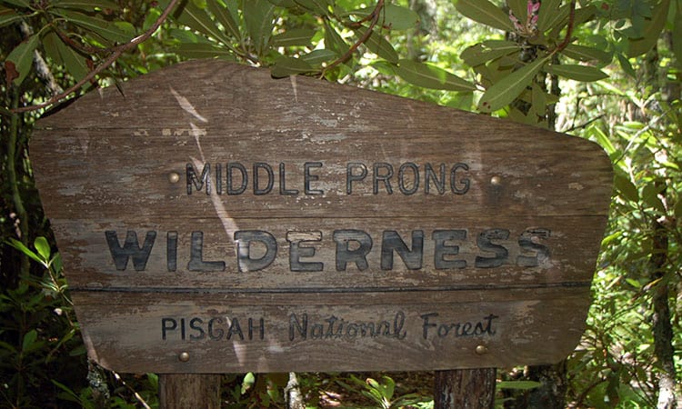
Middle Prong Wilderness
Located north of Brevard and the Blue Ridge Parkway, the Middle Prong Wilderness Area encompasses 7,900 acres of steep, rugged, high-elevation ridges ranging from 3,200 to over 6,400 feet. That makes it one of the least visited parts of the Pisgah National Forest, and a perfect place to find secluded trails and minimal signs of human impact. There are ample hiking options within the Middle Prong WA, including access to the Mountains-to-Sea Trail. However, signage is minimal, so plan your navigation accordingly. Middle Prong gets its name from the middle prong of the Pigeon River, whose headwaters are located in the area. Click for more info.
Hikes within Middle Prong Wilderness:
- Buckeye Gap Trail #126, 3.1 miles
- Green Mountain Trail #113, 5.0 miles
- Haywood Gap Trail #142, 6.0 miles
- Mountains to Sea National Recreation Trail #440, 39.7 miles
Length: 3.1–39.7 miles
Difficulty: Strenuous
Lake Julia Trail
Enjoy great views along the banks of Reasonover Creek to beautiful Lake Julia from this trail that rises only 250 feet in elevation. This five-hour hike includes a crossing at Little River, which must be forded at the beginning and end of the hike. In normal conditions, the water depth will not exceed 1.5 feet, but water levels and current can vary dramatically based on rainfall. River shoes with good traction are recommended. This route travels through the remote southern portion of DuPont State Forest, and the ford across the Little River limits foot traffic in this area of the forest. Click for more info.
Length: 10 miles round trip
Difficulty: Easy Moderate
Grab your gear and get outside! Find homes near your favorite hiking and biking trails. Search homes for sale in Brevard.
3 Secluded Trails near Hendersonville
Trombatore Trail
From Bearwallow Road in Fairview, get to know Hickory Nut Gap on the Trombatore Trail! Most hikers gravitate to Bearwallow Mountain, considered one of the best hikes around. But right across the road from that trailhead is the starting point for this lesser-known hike. Blazed in 2014, the heavy canopy keeps much of this trail shaded in the summer. Pass over creeks, through open fields, and along old stack-stone walls. After gaining 1,200 feet in elevation, you’ll reach a beautiful pasture at the summit that’s covered in wildflowers in the spring. It’s perfect for a private picnic! Click here for more info.
Length: 5.3 miles out and back
Difficulty: Moderate Strenuous
Turkey Pen Gap Loop
Turkey Pen Loop offers a great place to seek solitude and adventure within Pisgah National Forest. Travel along the banks of the South Fork Mills River, then ford the adult knee-level water to continue through rolling terrain and a peaceful hardwood forest. A suspension bridge takes you back across the river so you don’t have to get your feet wet again. The trail climbs around 400 feet over the course of your 2.5-hour hike. The rough road and river fording discourage many hikers and bikers. But this is one of the most popular horseback riding destinations in Pisgah. Click for more info.
Length: 4.6 miles round trip
Difficulty: Easy Moderate
Upper Fungi Falls
It’s possible to take this easy out-and-back trail in under 15 minutes. But why rush when you have it all to yourself! Park by the gate and walk down the kid-friendly gravel road. When you see a small tree with a red double blaze, turn left and follow the blazes through the trees to a small trail along a ridge. You can follow that trail to a waterfall below. The lower falls trail offers a more difficult experience for hikers (not kid-friendly) and tends to be a more popular route. The 30-foot waterfall cascades over beautifully colored layered rock. Click for more info.
Length: 0.5 miles out and back
Difficulty: Easy
Grab your gear and get outside! Find homes near your favorite hiking and biking trails. Search homes for sale in Hendersonville.
4 Secluded Trails near Waynesville
The Boogerman Trail
Cross one of the longest footbridges in Great Smoky Mountains National Park into an old growth forest on the Boogerman Trail. The trail gets its name from Robert Palmer, whose nickname was “Boogerman.” As you travel along the path, you will pass the former Palmer home site. An initial climb, along with another short, stiff climb near the half-way point, are the only stretches that keep Boogerman Trail from being anything other than a very pleasant walk in the woods. The park recommends traveling counterclockwise, but many hikers prefer the clockwise route. Ths trail is primarily used for hiking, running, and horses and is accessible year round. Click for more info.
Length: 7.3 miles round trip
Difficulty: Moderate
Cataloochee Divide Trail
If you’d rather see more wildlife than people, this trail is for you. Located in the heart of Great Smoky Mountains National Park, but away from tourist centers, the Cataloochee Valley offers scenic solitude at its finest. This four-season, out-and-back trail features beautiful wildflowers in spring. In summer, the high elevations (the trail gains 2,791 feet) offer cooler temperatures, and the fall and winter views are unmatched. The trail follows the park boundary, approaching “The Swag,” an open area with great views and a private resort of the same name. Take the intersecting Hemphill Bald Trail to the bald for lunch with a view. Horses are also able to use this trail. Click for more info.
Length: 13.8 miles
Difficulty: Strenuous
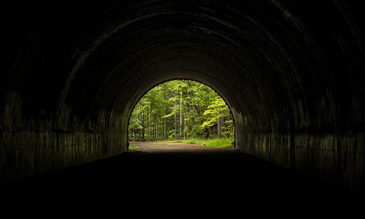
Little Tennessee Lakeshore Trail
If you are ready for a long weekend, enjoy the Little Tennessee Lakeshore Trail near Fontana Dam. The trail offers the adventurous some of the most quiet hiking in Great Smoky Mountains National Park. Start your hike from the “Road to Nowhere” by heading through the automotive tunnel that’s never seen an automobile. Travel vertically (with elevation changes of 5,459 feet) and horizontally along the length of Fontana Lake. There are a number of NPS-designated backcountry sites along this trail. Visitors must have a permit. Camping outside of established campsites is not permitted. You can fish in the lake for trout and smallmouth bass. Click for more info.
Length: 32.6 miles
Difficulty: Strenuous
Mountains-to-Sea Trail: Woodfin Overlook
At 935 miles, the MST covers a lot of challenging terrain. But there are also many easy sections that go untraveled by casual hikers. The 1.6-mile out-and-back Woodfin Overlook Trail is one such route. This great hiking trail can be easily traversed in under an hour, making it a great kid-friendly option. But there are also a couple creek crossings and seasonal road closures to consider, depending on weather and the season. Hikers report lots of ferns and mushrooms along the route, which begins at the Woodfin Cascades Overlook of the Blue Ridge Parkway. Click for more info.
Length: 1.6 miles
Difficulty: Easy
Grab your gear and get outside! Find homes near your favorite hiking and biking trails. Search homes for sale in Waynesville.
What is NC Year of the Trail?
Allen Tate/Beverly-Hanks is proud to be an Official Sponsor of NC Year of the Trail! This year-long endeavor celebrates our state’s vast network of trails, greenways, and blueways—and is the largest statewide celebration of trails and outdoor recreation in North Carolina history!
North Carolina is the Great Trails State, where each of North Carolina’s 100 counties should be able to enjoy the proven benefits of trails, including health, safety, economic development, tourism, transportation, and environment. Trails are the backbone of our state’s growing $28 billion outdoor recreation economy.
No matter your age, background, or abilities, there is a trail out there for you! We hope you’re inspired by today’s post on secluded trails in WNC. Check back as the year progresses; we’ll be covering more topics related to the NC Year of the Trail, including:
- Accessible rail trails and greenways.
- Unexpected trail options beyond hiking.
- Trails with additional perks.
- And more.